Philip's World Desk Map
by
ISBN-10: 0540091545
ISBN-13: 9780540091546
-
Book Specs
Binding
Trade Cloth
Publisher
Philip's
Published on
Sep 24, 2007
Edition
st Edition
Dimensions
12.20x0.08x17.91 Inches
Weight
0.15 Pounds
About the Book
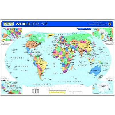
New for 2007, this double-sided desk map has been specially created for use in the classroom or at home. The map is encapsulated, making it both durable and suitable for write-on/wipe-off with water-soluble marker pens or chinagraph crayons.Side 1 shows the World in political colours at a scale of 1:90 000 000 (1 cm on the map = 900 km on the ground), with clear lettering and symbols for easy reference. Individual countries are picked out in bright distinctive colours to aid identification, with major towns and cities marked, as well as major rivers. Larger-scale political maps are also provided on Side 1 for the crowded regions of Europe and the Caribbean (each at a scale of 1:48 000 000), and there are additional maps of the Arctic Ocean and Antarctica (each at a scale of 1:120 000 000) in political colours.Side 2 shows the World in physical colours at a scale of 1:90 000 000 (1 cm on the map = 900 km on the ground). The use of hill-shading with layer-colouring gives an outstanding visual impression of the landscape, with mountains, rivers and lakes clearly shown. Extra maps are also provided for the Arctic Ocean and Antarctica (at a scale of 1:120 000 000), together with tables of World Facts and World Records (such as, the World's highest mountain, longest river, largest island, etc).Main map projection: Hammer Equal Area.